Watching Close to the Blue Line in Minneapolis
![]()
Target Field
Warehouse District/Hennepin Ave
Nicollet Mall
Government Plaza
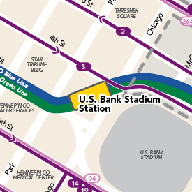
U.S. Bank Stadium
Cedar / Riverside
Franklin Avenue
Lake Street / Midtown
38th St
46th St
50th Street / Minnehaha Park
VA Medical Center
Fort Snelling![]()
Terminal 1![]()
Terminal 2![]()
American Boulevard
Bloomington Central
30th Avenue![]()
Mall of America
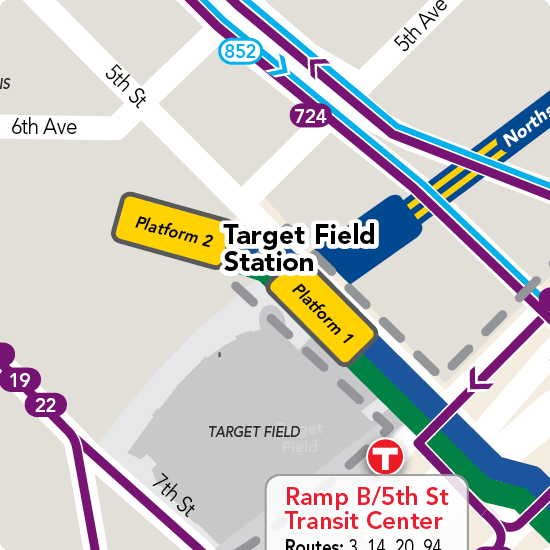
Target Field Station
335 Fifth Street North
Connecting routes:
Northstar Commuter Rail serves the station's lower level
Bicycle connections to Northstar
Station enclosure is open:
Monday-Friday 5 to 9 a.m. and 2:30 to 6:30 p.m.
Saturday 10:30 a.m. to 7:30 p.m.
Sunday 9:30 a.m. to 5:30 p.m.
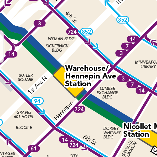
Warehouse District / Hennepin Avenue Station
23 North 5th Street
Many downtown bus routes – see map
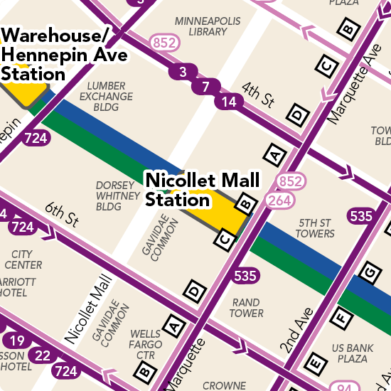
Nicollet Mall Station
35 South 5th Street
Connecting routes:
Many downtown bus routes – see map
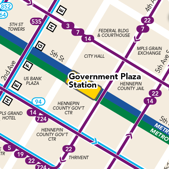
Government Plaza Station
352 South 5th Street
Connecting routes:
Many downtown bus routes – see map
U.S. Bank Stadium Station
429 Park Avenue South
Connecting routes:
> 3 - serves Rice Street, Dinkytown, U of M and downtown Minneapolis
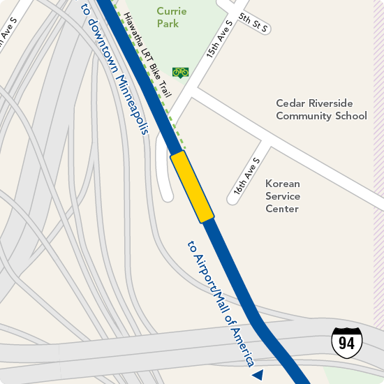
Cedar / Riverside Station
613 15th Avenue South
Connecting bus routes:
No connecting bus routes, though Route 22 – serving south Minneapolis, downtown Minneapolis, north Minneapolis and Brooklyn Center – travels on Cedar Avenue. Follow signs from station "to Cedar Avenue buses."
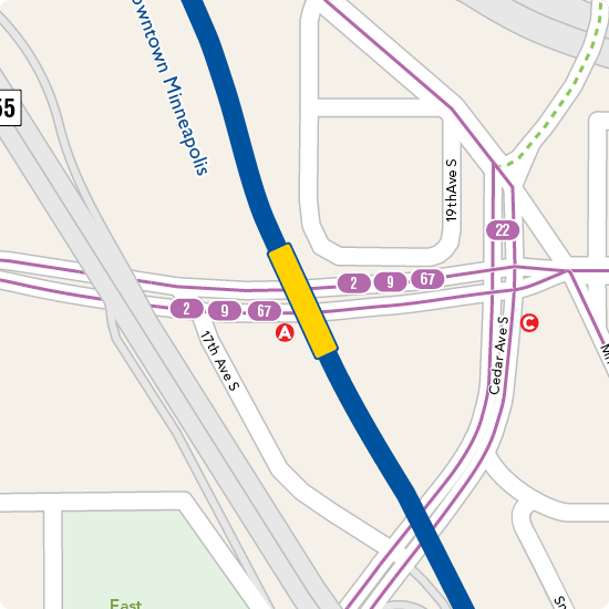
Franklin Avenue Station
1808 Franklin Avenue East
Connecting bus routes:
> 2 - serves Uptown Minneapolis, West Bank Station (METRO Green Line) and U of M
> 9 - serves south Minneapolis, downtown Minneapolis, Golden Valley, St. Louis Park and Minnetonka
> 22 - serves Brooklyn Center, north Minneapolis, downtown Minneapolis, West Bank Station (METRO Green Line), Cedar Avenue and south Minneapolis
> 67 - serves W Minnehaha - Raymond Sta -Hiawatha
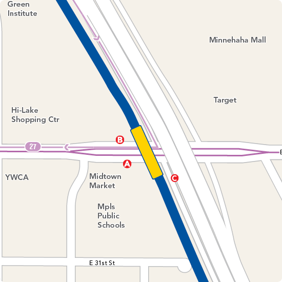
Lake Street / Midtown Station
2310 Lake Street East
Connecting bus routes:
> 21 - serves downtown St. Paul, Snelling Avenue Station (METRO Green Line), Midway Shopping Center, St. Thomas, Uptown Transit Station
> 27 - serves south Minneapolis, I-35W & Lake Street, Lake Street/Midtown Station
> 53 - this limited-stop route serves the same area as Route 21 (weekdays only)
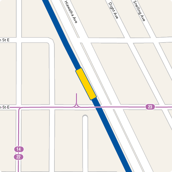
38th Street Station
2902 38th Street East
Connecting bus routes:
> 14 - serves Richfield, south Minneapolis (Bloomington Avenue), north Minneapolis, Robbinsdale
> 22 - serves VA Medical Center, downtown Minneapolis, Lyndale Avenue, Brooklyn Center
> 23 - serves Highland Park, 38th Street, Uptown Transit Station
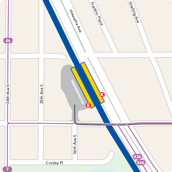
46th Street Station
3660 46th Street East
Connecting bus routes:
> A Line - serves Rosedale, HarMar Mall, Snelling Ave. Station (METRO Green Line), Midway Shopping Center and Highland Park
> 7 - serves south Minneapolis, downtown Minneapolis, north Minneapolis
> 9 - serves south Minneapolis, downtown Minneapolis, Golden Valley, St. Louis Park and Minnetonka
> 46 - serves Edina, 46th Street, Highland Park, Cleveland Avenue, Sibley Plaza
> 74- serves Highland Park, Randolph Avenue, St. Catherine's University, downtown St. Paul, Sun Ray, Oakdale
> 436 - serves Eagan, Mendota Heights, Thomson Reuters, Brown College, south Minneapolis
> 446 - serves Eagan Transit Station, Mendota Heights, south Minneapolis
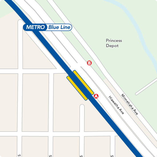
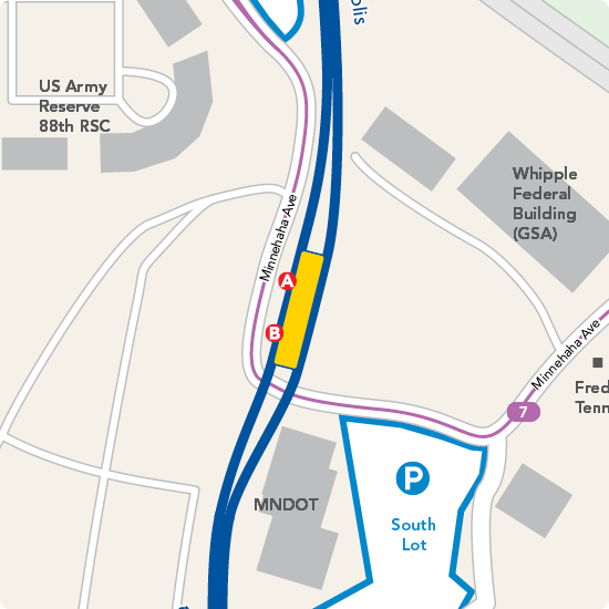
50th Street / Minnehaha Park Station
5010 Hiawatha Avenue
No connecting bus routes
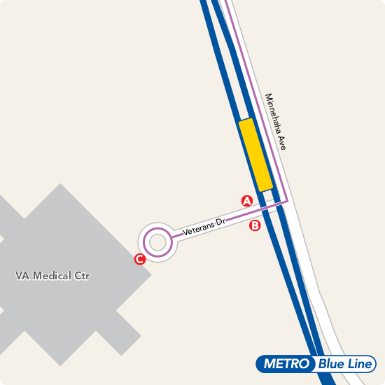
VA Medical Center Station
5504 Minnehaha Avenue
Connecting bus routes:
> 22 - serves VA Medical Center, downtown Minneapolis, Lyndale Avenue, Brooklyn Center
> 440 - serves Apple Valley Transit Station, Minnesota Zoo, Cedar Grove Transit Station
> 515 - Southdale, 66th Street, Cedar Avenue, 8100 Building
Fort Snelling Station
5801 Minnehaha Avenue
Connecting bus routes:
> 7- serves south Minneapolis, downtown Minneapolis, north Minneapolis
Overnight parking is available for up to 24 hours in dedicated spaces in the Park & Ride North Lot. Please be aware that lots are monitored and violators will be ticketed and/or towed.
Terminal 1 Station
6450 Glumack Drive
> See which airlines serve this terminal
Connecting bus routes:
> 54 - serves Mall of America, downtown St. Paul
> More information about airport service
City bus and train service is available at the Transit Station, located on the east side of the Blue and Red parking ramps. To reach the station, follow the Ground Transportation signs to the lower level, then take the tram.
To board trains, take the escalator down one level from the tram level and purchase a rail ticket at the ticket machine. Continue down another escalator to the METRO platform.
To board buses, take the escalator up one level (street level) from the tram level.
Blue Line trains operate 24 hours a day between the Terminal 1–Lindbergh and Terminal 2 –Humphrey stations. No fare is required for trips between terminals.
Terminal 2 Station
7115 Humphrey Drive
> See which airlines serve this terminal
No connecting bus routes
Blue Line trains operate 24 hours a day between Terminal 1–Lindbergh and Terminal 2–Humphrey stations. No fare is required for trips between terminals.
> More information about airport service
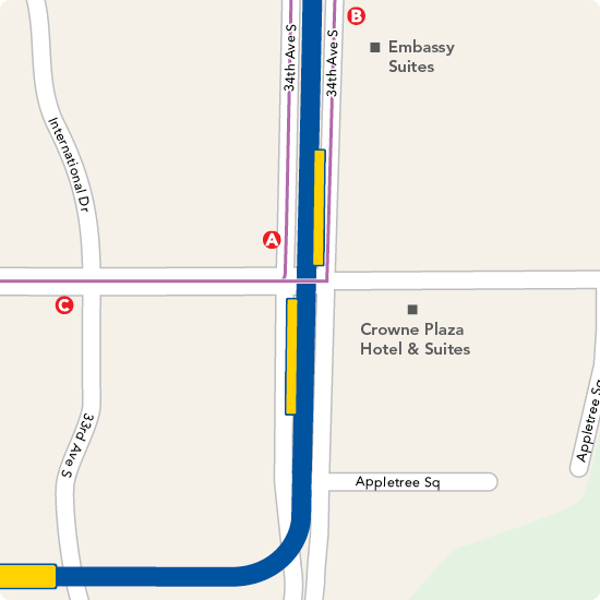
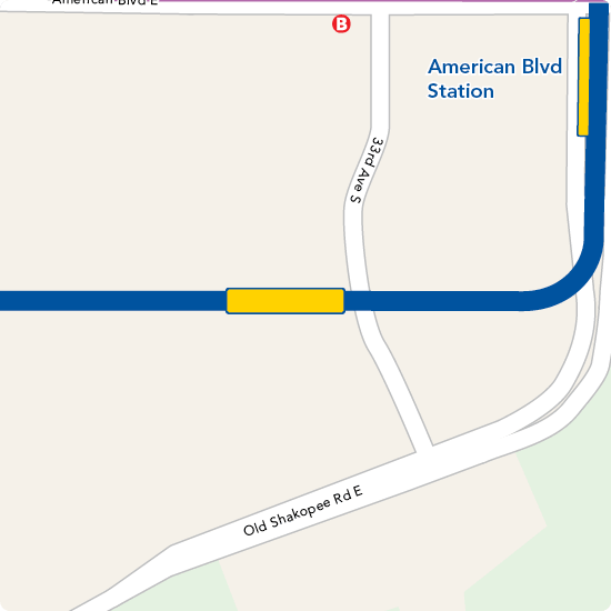
American Boulevard Station
3397-3398 American Boulevard East
No connecting bus routes
Bloomington Central Station
8101 31st Avenue South
No connecting bus routes
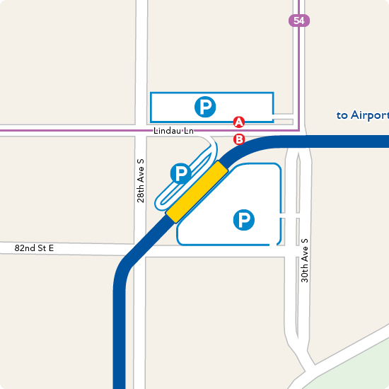
30th Avenue Station
8101 Winstead Way
Connecting bus routes:
> 54 - serves Mall of America, Terminal 1 Station and downtown St. Paul.
Overnight parking is available for up to 24 hours in dedicated spaces on the fourth level of this Park & Ride ramp. Please be aware that lots are monitored and violators will be ticketed and/or towed.
Mall of America Station
8240 24th Avenue South - lower level, East Broadway
Note: There are no Park & Ride spaces at Mall of America. Please use the free parking spaces at 30th Avenue Station or Fort Snelling Station.
Connecting bus routes:
> METRO Red Line - frequent, all-day service to Eagan, Apple Valley
> 5 - serves Richfield, south Minneapolis, downtown Minneapolis, north Minneapolis and Brooklyn Center
> 54 - serves Mall of America, Terminal 1 Station and downtown St. Paul (Union Depot Station - METRO Green Line)
> 415 - serves Mendota Heights, Eagan
> 444 - serves Burnsville, Bloomington, Savage
> 515 - serves Southdale, 66th Street, Cedar Avenue, 8100 Building
> 538 - serves Edina, Southdale, Best Buy, Southtown Shopping Center
> 539 - serves Richfield, Best Buy, Normandale College, Southtown Shopping Center
> 540 - serves Edina, Richfield, MN Drive Transit Center, 76th St. Transit Center, Bloomington
> 542 - serves Richfield, Best Buy, Normandale Lake Office Park, Southtown Shopping Center, Bloomington
Source: https://www.metrotransit.org/blue-line-station-maps
0 Response to "Watching Close to the Blue Line in Minneapolis"
Post a Comment